


Victor Voting District, Mason County, Washington
About
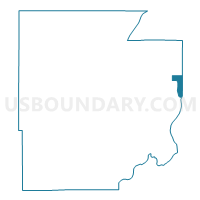
Outline

Summary
| Unique Area Identifier | 687583 |
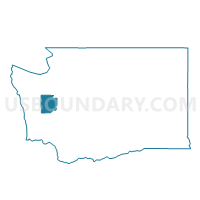
| Name | Victor Voting District |
| County | Mason County |
| State | Washington |
| Area (square miles) | 4.89 |
| Land Area (square miles) | 3.72 |
| Water Area (square miles) | 1.17 |
| % of Land Area | 76.15 |
| % of Water Area | 23.85 |
| Latitude of the Internal Point | 47.40529840 |
| Longtitude of the Internal Point | -122.81896400 |
Maps

Graphs
Select a template below for downloading or customizing gragh for Victor Voting District, Mason County, Washington


Neighbors
Neighoring Voting District (by Name) Neighboring Voting District on the Map
- Voting District 26-211, Pierce County, WA
- Allyn Voting District, Mason County, WA
- Belfair 5 Voting District, Mason County, WA
- Dickenson Voting District, Kitsap County, WA
- Grapeview Voting District, Mason County, WA
- Lakeland Voting District, Mason County, WA
- Water: Case Inlet Leg 26, Pierce County, WA
Top 10 Neighboring County Subdivision (by Population) Neighboring County Subdivision on the Map
- Port Orchard CCD, Kitsap County, WA (67,580)
- Key Peninsula-Anderson Island CCD, Pierce County, WA (15,595)
- Union-Grapeview CCD, Mason County, WA (13,303)
- Belfair-Tahuya CCD, Mason County, WA (8,737)
Top 10 Neighboring Place (by Population) Neighboring Place on the Map
Top 10 Neighboring Unified School District (by Population) Neighboring Unified School District on the Map
- South Kitsap School District, WA (68,017)
- Peninsula School District, WA (61,651)
- North Mason School District, WA (14,752)
- Grapeview School District, WA (2,567)
Top 10 Neighboring State Legislative District Lower Chamber (by Population) Neighboring State Legislative District Lower Chamber on the Map
Top 10 Neighboring State Legislative District Upper Chamber (by Population) Neighboring State Legislative District Upper Chamber on the Map
Top 10 Neighboring 111th Congressional District (by Population) Neighboring 111th Congressional District on the Map
Top 10 Neighboring Census Tract (by Population) Neighboring Census Tract on the Map
- Census Tract 9604, Mason County, WA (8,817)
- Census Tract 929.01, Kitsap County, WA (5,645)
- Census Tract 726.01, Pierce County, WA (5,235)